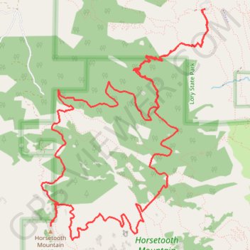
Lamier State Park to Horse Tooth Mountain
Larimer County Vandring
- Distance: 17.1 Km
- Elevation gain: 718 m
- Maximum elevation: 2,186 m
- Elevation loss: 714 m
- Minimum elevation: 1,709 m
- Moving time: 5 h 3 m
- Moving speed: 3.4 Km/h
- Maximum speed: 12.8 Km/h
- Total time: 6 h 40 s
- Global speed: 2.8 Km/h
Interactive trail map
Trail profile
- Distance: 17.1 Km
- Elevation gain: 718 m
- Maximum elevation: 2,186 m
- Elevation loss: 714 m
- Minimum elevation: 1,709 m
- Moving time: 5 h 3 m
- Moving speed: 3.4 Km/h
- Maximum speed: 12.8 Km/h
- Total time: 6 h 40 s
- Global speed: 2.8 Km/h
About this trail
Name: Lamier State Park to Horse Tooth Mountain trail, distance, elevation, map, profile, GPS track
Start: Lodgepole Drive, Larimer County, Colorado, United States (40.56441 -105.17426)
End: Aurthurs Rock / West Valley Trail, Larimer County, Colorado, United States (40.56433 -105.17477)
Coordinates: 40.53873 -105.19815 40.56441 -105.17379