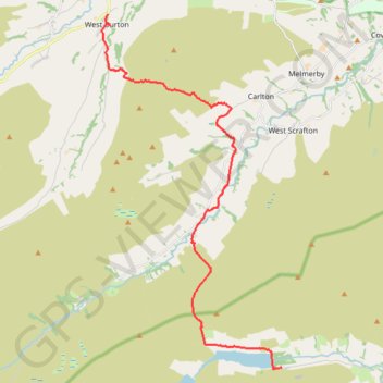
Hike from Scar House Reservoir to West Burton
Walking @ North Yorkshire
- Distance: 18.2 Km
- Elevation gain: 476 m
- Maximum elevation: 486 m
- Elevation loss: 650 m
- Minimum elevation: 157 m
- Moving time: 4 h 17 m
- Moving speed: 4.3 Km/h
- Maximum speed: 8.0 Km/h
- Total time: 4 h 54 m
- Global speed: 3.7 Km/h
Interactive trail map
Trail profile
- Distance: 18.2 Km
- Elevation gain: 476 m
- Maximum elevation: 486 m
- Elevation loss: 650 m
- Minimum elevation: 157 m
- Moving time: 4 h 17 m
- Moving speed: 4.3 Km/h
- Maximum speed: 8.0 Km/h
- Total time: 4 h 54 m
- Global speed: 3.7 Km/h
About this trail
Name: Hike from Scar House Reservoir to West Burton trail, distance, elevation, map, profile, GPS track
Coordinates: 54.18549 -1.97597 54.27893 -1.89484
Other hiking, mountain biking, running and outdoor activity trails
Click on a trail to view its statistics, map and profile.
Hike from Scar House to East Witton
United Kingdom > England > North Yorkshire > Lofthouse > Middlesmoor
Distance: 17.3 Km • Elevation gain: 415 m • Maximum elevation: 487 m