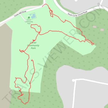
Carter community park
- Distance: 2.5 Km
- Elevation gain: 42 m
- Maximum elevation: 326 m
- Elevation loss: 64 m
- Minimum elevation: 276 m
- Moving time: 38 m 53 s
- Moving speed: 3.8 Km/h
- Maximum speed: 14.2 Km/h
- Total time: 40 m 7 s
- Global speed: 3.7 Km/h
Interactive trail map
Trail profile
- Distance: 2.5 Km
- Elevation gain: 42 m
- Maximum elevation: 326 m
- Elevation loss: 64 m
- Minimum elevation: 276 m
- Moving time: 38 m 53 s
- Moving speed: 3.8 Km/h
- Maximum speed: 14.2 Km/h
- Total time: 40 m 7 s
- Global speed: 3.7 Km/h
About this trail
Name: Carter community park trail, distance, elevation, map, profile, GPS track
Coordinates: 36.01468 -83.71670 36.02030 -83.71117
Other hiking, mountain biking, running and outdoor activity trails
Click on a trail to view its statistics, map and profile.
Comfort Suites Airport - Shady Valley Country Store
United States > Tennessee > Blount County > Alcoa > Farrport
146 mi, 2:28
Distance: 235.4 Km • Elevation gain: 3,292 m • Maximum elevation: 1,045 m