Town Creek - Lake Guntersville
Town Creek from Guntersville Lake to rocks - kayak, town creek, guntersville
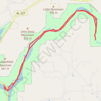
- Distance: 18.8 Km
- Elevation gain: 142 m
- Maximum elevation: 197 m
- Elevation loss: 141 m
- Minimum elevation: 178 m
- Moving time: 3 h 7 m
- Moving speed: 6.0 Km/h
- Maximum speed: 8.4 Km/h
- Total time: 3 h 51 m
- Global speed: 4.9 Km/h
Interactive trail map
Trail profile
- Distance: 18.8 Km
- Elevation gain: 142 m
- Maximum elevation: 197 m
- Elevation loss: 141 m
- Minimum elevation: 178 m
- Moving time: 3 h 7 m
- Moving speed: 6.0 Km/h
- Maximum speed: 8.4 Km/h
- Total time: 3 h 51 m
- Global speed: 4.9 Km/h
About this trail
Name: Town Creek - Lake Guntersville trail, distance, elevation, map, profile, GPS track
Start: 11762, AL 227, Guntersville, Marshall County, Alabama, 35976, United States (34.40692 -86.17983)
End: 11685, AL 227, Guntersville, Marshall County, Alabama, 35976, United States (34.40605 -86.17917)
Coordinates: 34.40414 -86.17983 34.44419 -86.12335