Munro hillwalk Strathfarrar Rguidhe Gobhar Ghlais Fhuar-thuill
Munro, hillwalk, Strathfarrar, Rguidhe, Gobhar, Ghlais, Fhuar-thuill
- Distance: 27.1 Km
- Elevation gain: 1,647 m
- Maximum elevation: 1,076 m
- Elevation loss: 1,647 m
- Minimum elevation: 133 m
- Moving time: 7 h 7 m
- Moving speed: 3.8 Km/h
- Maximum speed: 30.4 Km/h
- Total time: 8 h 7 m
- Global speed: 3.3 Km/h
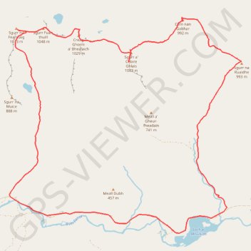
Interactive trail map
Trail profile
- Distance: 27.1 Km
- Elevation gain: 1,647 m
- Maximum elevation: 1,076 m
- Elevation loss: 1,647 m
- Minimum elevation: 133 m
- Moving time: 7 h 7 m
- Moving speed: 3.8 Km/h
- Maximum speed: 30.4 Km/h
- Total time: 8 h 7 m
- Global speed: 3.3 Km/h
About this trail
Name: Munro hillwalk Strathfarrar Rguidhe Gobhar Ghlais Fhuar-thuill trail, distance, elevation, map, profile, GPS track
Start: Glencannich Road, Cannich, Highland, Scotland, IV4 7LX, United Kingdom (57.40571 -4.85932)
End: Glencannich Road, Cannich, Highland, Scotland, IV4 7LX, United Kingdom (57.40563 -4.85931)
Coordinates: 57.39922 -4.95860 57.45231 -4.85245
Other hiking, mountain biking, running and outdoor activity trails
Click on a trail to view its statistics, map and profile.
Loch Ness
United Kingdom > Scotland > Highland > Lochcarron
Distance: 106.7 Km • Elevation gain: 1,584 m • Maximum elevation: 280 m