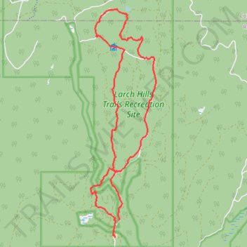
Larch Hills backcountry nordic trails: Blue Sky, Pileated Promenade and 4 bogs route
- Distance: 13.4 Km
- Elevation gain: 277 m
- Maximum elevation: 1,240 m
- Elevation loss: 291 m
- Minimum elevation: 997 m
- Moving time: 2 h 1 m
- Moving speed: 6.7 Km/h
- Maximum speed: 36.6 Km/h
- Total time: 2 h 14 m
- Global speed: 6.0 Km/h
Interactive trail map
Trail profile
- Distance: 13.4 Km
- Elevation gain: 277 m
- Maximum elevation: 1,240 m
- Elevation loss: 291 m
- Minimum elevation: 997 m
- Moving time: 2 h 1 m
- Moving speed: 6.7 Km/h
- Maximum speed: 36.6 Km/h
- Total time: 2 h 14 m
- Global speed: 6.0 Km/h
About this trail
Name: Larch Hills backcountry nordic trails: Blue Sky, Pileated Promenade and 4 bogs route trail, distance, elevation, map, profile, GPS track
Coordinates: 50.70887 -119.14321 50.75285 -119.12343
Other hiking, mountain biking, running and outdoor activity trails
Click on a trail to view its statistics, map and profile.
Salmon Arm - Sicamous
Canada > British Columbia > Salmon Arm > Switsemalph 6
Lake Shuswap. #Bike
Distance: 40.6 Km • Elevation gain: 456 m • Maximum elevation: 501 m