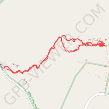
Hinterlands - White Mountain National Forest
- Distance: 2.4 Km
- Elevation gain: 191 m
- Maximum elevation: 341 m
- Elevation loss: 193 m
- Minimum elevation: 196 m
- Moving time: 1 h 1 m
- Moving speed: 2.3 Km/h
- Maximum speed: 5.0 Km/h
- Total time: 4 h 11 m
- Global speed: 0.6 Km/h
Interactive trail map
Trail profile
- Distance: 2.4 Km
- Elevation gain: 191 m
- Maximum elevation: 341 m
- Elevation loss: 193 m
- Minimum elevation: 196 m
- Moving time: 1 h 1 m
- Moving speed: 2.3 Km/h
- Maximum speed: 5.0 Km/h
- Total time: 4 h 11 m
- Global speed: 0.6 Km/h
About this trail
Name: Hinterlands - White Mountain National Forest trail, distance, elevation, map, profile, GPS track
Coordinates: 43.80337 -71.85076 43.80549 -71.84302
Other hiking, mountain biking, running and outdoor activity trails
Click on a trail to view its statistics, map and profile.