Thank you for supporting this site ❤️
Make a donation
Make a donation
Evening Hike
- Distance: 4.6 Km
- Elevation gain: 61 m
- Maximum elevation: 339 m
- Elevation loss: 61 m
- Minimum elevation: 305 m
- Moving time: 1 h 1 m
- Moving speed: 4.5 Km/h
- Maximum speed: 6.9 Km/h
- Total time: 1 h 19 m
- Global speed: 3.5 Km/h
Interactive trail map
Thank you for supporting this site ❤️
Make a donation
Make a donation
Trail profile
- Distance: 4.6 Km
- Elevation gain: 61 m
- Maximum elevation: 339 m
- Elevation loss: 61 m
- Minimum elevation: 305 m
- Moving time: 1 h 1 m
- Moving speed: 4.5 Km/h
- Maximum speed: 6.9 Km/h
- Total time: 1 h 19 m
- Global speed: 3.5 Km/h
Thank you for supporting this site ❤️
Make a donation
Make a donation
About this trail
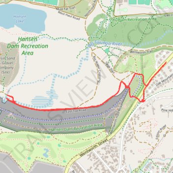
Name: Evening Hike trail, distance, elevation, map, profile, GPS track
Coordinates: 34.26026 -118.38493 34.26466 -118.36728
Thank you for supporting this site ❤️
Make a donation
Make a donation
Other hiking, mountain biking, running and outdoor activity trails
Click on a trail to view its statistics, map and profile.
Hansen Dam Lake loop
United States > California > Los Angeles County > Los Angeles
Distance: 6.5 Km • Elevation gain: 40 m • Maximum elevation: 316 m
Hansen Dam East
United States > California > Los Angeles County > Los Angeles
Distance: 4.7 Km • Elevation gain: 59 m • Maximum elevation: 332 m
Hansen Dam
United States > California > Los Angeles County > Los Angeles
Distance: 2.7 Km • Elevation gain: 50 m • Maximum elevation: 344 m