Walk to source of forest track
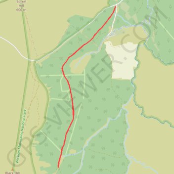
Ballydonnel North Track
- Distance: 6.2 Km
- Elevation gain: 128 m
- Maximum elevation: 424 m
- Elevation loss: 127 m
- Minimum elevation: 340 m
- Moving time: 55 m 30 s
- Moving speed: 6.7 Km/h
- Maximum speed: 7.3 Km/h
- Total time: 59 m 42 s
- Global speed: 6.3 Km/h
Interactive trail map
Trail profile
- Distance: 6.2 Km
- Elevation gain: 128 m
- Maximum elevation: 424 m
- Elevation loss: 127 m
- Minimum elevation: 340 m
- Moving time: 55 m 30 s
- Moving speed: 6.7 Km/h
- Maximum speed: 7.3 Km/h
- Total time: 59 m 42 s
- Global speed: 6.3 Km/h
About this trail
Name: Walk to source of forest track trail, distance, elevation, map, profile, GPS track
Coordinates: 53.12226 -6.43385 53.14627 -6.41957
Other hiking, mountain biking, running and outdoor activity trails
Click on a trail to view its statistics, map and profile.
Mullaghcleevaun and Black Hill Loop
Wicklow Mountains National Park
Distance: 14.1 Km • Elevation gain: 564 m • Maximum elevation: 844 m