JULIANA BIKE - stage 1: Bohinjska Bistrica - Goreljek
Along the Sava Bohinjka River to Lake Bohinj and upwards to Pokljuka
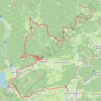
- Distance: 31.7 Km
- Elevation gain: 1,232 m
- Maximum elevation: 1,384 m
- Elevation loss: 478 m
- Minimum elevation: 502 m
Interactive trail map
Trail profile
- Distance: 31.7 Km
- Elevation gain: 1,232 m
- Maximum elevation: 1,384 m
- Elevation loss: 478 m
- Minimum elevation: 502 m
About this trail
Name: JULIANA BIKE - stage 1: Bohinjska Bistrica - Goreljek trail, distance, elevation, map, profile, GPS track
Start: Triglavska cesta, Bohinjska Bistrica, Bohinj, 4264, Slovenia (46.27343 13.94957)
End: 906, Bled, Bohinj, Slovenia (46.33861 13.96181)
Coordinates: 46.26931 13.88644 46.33861 13.97592
Other hiking, mountain biking, running and outdoor activity trails
Click on a trail to view its statistics, map and profile.