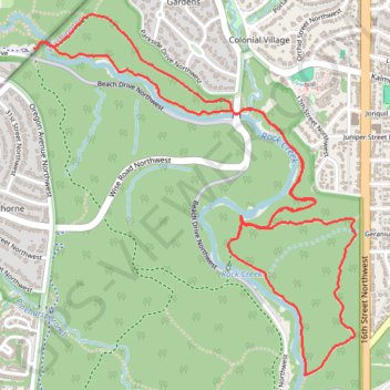
Rock Creek Loop via Valley Trail, Holly Trail, Pine Trail and Muddy Trail in Rock Creek Park and Piney Branch Parkway
This Rock Creek Loop, which traverses the Valley Trail, Holly Trail, Pine Trail, and Muddy Trail, offers a delightful blend of serene wooded paths, charming creek views, and diverse wildlife, making it an ideal choice for nature enthusiasts seeking a peaceful escape within the city. The trails are mostly shaded and feature gentle elevation changes, enhancing the overall experience while providing ample opportunities for relaxation along the way. #Hiking #Loop #River #Forest #Nature
- Distance: 6.8 Km
- Elevation gain: 121 m
- Maximum elevation: 102 m
- Elevation loss: 123 m
- Minimum elevation: 52 m
- Moving time: 1 h 19 m
- Moving speed: 5.1 Km/h
- Maximum speed: 7.8 Km/h
- Total time: 1 h 23 m
- Global speed: 4.9 Km/h
Interactive trail map
Trail profile
- Distance: 6.8 Km
- Elevation gain: 121 m
- Maximum elevation: 102 m
- Elevation loss: 123 m
- Minimum elevation: 52 m
- Moving time: 1 h 19 m
- Moving speed: 5.1 Km/h
- Maximum speed: 7.8 Km/h
- Total time: 1 h 23 m
- Global speed: 4.9 Km/h
About this trail
Name: Rock Creek Loop via Valley Trail, Holly Trail, Pine Trail and Muddy Trail in Rock Creek Park and Piney Branch Parkway trail, distance, elevation, map, profile, GPS track
Coordinates: 38.97382 -77.05309 38.98798 -77.03683
Other hiking, mountain biking, running and outdoor activity trails
Click on a trail to view its statistics, map and profile.
Rock Creek Park Loop via Western Ridge Trail and Valley Trail
The Rock Creek Park Loop via the Western Ridge Trail and Valley Trail offers a scenic blend of lush woodlands, meandering creeks, and diverse wildlife, providing a refreshing escape into nature while still being conveniently accessible from the city. #Hiking #Loop #River #Forest #Nature
Distance: 16.6 Km • Elevation gain: 293 m • Maximum elevation: 101 m