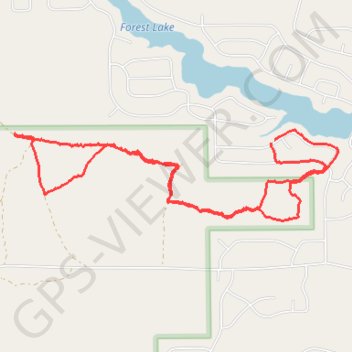
Some trails near Forest Lake, Michigan
- Distance: 8.2 Km
- Elevation gain: 27 m
- Maximum elevation: 240 m
- Elevation loss: 27 m
- Minimum elevation: 230 m
- Moving time: 1 h 54 m
- Moving speed: 4.3 Km/h
- Maximum speed: 8.6 Km/h
- Total time: 1 h 57 m
- Global speed: 4.2 Km/h
Interactive trail map
Trail profile
- Distance: 8.2 Km
- Elevation gain: 27 m
- Maximum elevation: 240 m
- Elevation loss: 27 m
- Minimum elevation: 230 m
- Moving time: 1 h 54 m
- Moving speed: 4.3 Km/h
- Maximum speed: 8.6 Km/h
- Total time: 1 h 57 m
- Global speed: 4.2 Km/h
About this trail
Name: Some trails near Forest Lake, Michigan trail, distance, elevation, map, profile, GPS track
Coordinates: 44.11337 -84.08537 44.11942 -84.05485