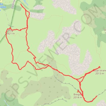
Zelengora - Bregoc - Kozije strane - Stog
- Distance: 12.6 Km
- Elevation gain: 854 m
- Maximum elevation: 2,000 m
- Elevation loss: 854 m
- Minimum elevation: 1,479 m
- Moving time: 3 h 29 m
- Moving speed: 3.6 Km/h
- Maximum speed: 7.1 Km/h
- Total time: 4 h 36 m
- Global speed: 2.7 Km/h
Interactive trail map
Trail profile
- Distance: 12.6 Km
- Elevation gain: 854 m
- Maximum elevation: 2,000 m
- Elevation loss: 854 m
- Minimum elevation: 1,479 m
- Moving time: 3 h 29 m
- Moving speed: 3.6 Km/h
- Maximum speed: 7.1 Km/h
- Total time: 4 h 36 m
- Global speed: 2.7 Km/h
About this trail
Name: Zelengora - Bregoc - Kozije strane - Stog trail, distance, elevation, map, profile, GPS track
Start: NPS2, Govza, Foča Municipality (RS), Republika Srpska, Bosnia and Herzegovina (43.37607 18.54831)
End: NPS2, Govza, Foča Municipality (RS), Republika Srpska, Bosnia and Herzegovina (43.37606 18.54836)
Coordinates: 43.35171 18.54337 43.37607 18.57546
Other hiking, mountain biking, running and outdoor activity trails
Click on a trail to view its statistics, map and profile.
Zelengora: 4 Jezera i Vrh Bregoč
Bosnia and Herzegovina > Republika Srpska
Distance: 24.3 Km • Elevation gain: 892 m • Maximum elevation: 1,987 m
2022_Yu
Slovenia > Ajdovščina > Žapuže
Distance: 2,457.3 Km • Elevation gain: 32,048 m • Maximum elevation: 1,950 m
Track 143
Bosnia and Herzegovina > Federation of Bosnia and Herzegovina > Ćusine > Donje Mile
8. 6. 2024 9:22 am
Distance: 346.1 Km • Elevation gain: 5,851 m • Maximum elevation: 1,228 m