Willow Hole
Hike to Willow Hole by the Boy Scout Trail and the Willow Hole Trail via the Mustang Ranch, the Bear Island and the Wonderland of Rocks in the Joshua Tree National Park. #Hiking #Nature #Rocks #Desert #Park
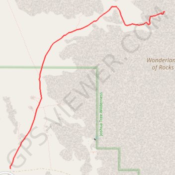
- Distance: 5.6 Km
- Elevation gain: 61 m
- Maximum elevation: 1,270 m
- Elevation loss: 53 m
- Minimum elevation: 1,230 m
Interactive trail map
Trail profile
- Distance: 5.6 Km
- Elevation gain: 61 m
- Maximum elevation: 1,270 m
- Elevation loss: 53 m
- Minimum elevation: 1,230 m
About this trail
Name: Willow Hole trail, distance, elevation, map, profile, GPS track
Start: Boy Scout Trail, San Bernardino County, California, United States (34.04111 -116.18574)
Coordinates: 34.04111 -116.18580 34.06980 -116.15278
Other hiking, mountain biking, running and outdoor activity trails
Click on a trail to view its statistics, map and profile.
Boy Scout Trail
United States > California > San Bernardino County
Distance: 13.4 Km • Elevation gain: 446 m • Maximum elevation: 1,278 m