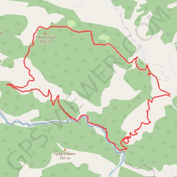
Tisovik - reka Ljubovidja
- Distance: 11.6 Km
- Elevation gain: 698 m
- Maximum elevation: 946 m
- Elevation loss: 694 m
- Minimum elevation: 397 m
- Moving time: 3 h 28 m
- Moving speed: 3.3 Km/h
- Maximum speed: 61.5 Km/h
- Total time: 3 h 58 m
- Global speed: 2.9 Km/h
Interactive trail map
Trail profile
- Distance: 11.6 Km
- Elevation gain: 698 m
- Maximum elevation: 946 m
- Elevation loss: 694 m
- Minimum elevation: 397 m
- Moving time: 3 h 28 m
- Moving speed: 3.3 Km/h
- Maximum speed: 61.5 Km/h
- Total time: 3 h 58 m
- Global speed: 2.9 Km/h
About this trail
Name: Tisovik - reka Ljubovidja trail, distance, elevation, map, profile, GPS track
Coordinates: 44.23507 19.53801 44.25512 19.57487
Other hiking, mountain biking, running and outdoor activity trails
Click on a trail to view its statistics, map and profile.
2022_Yu
Slovenia > Ajdovščina > Žapuže
Distance: 2,457.3 Km • Elevation gain: 32,048 m • Maximum elevation: 1,950 m