Bluestone State Park
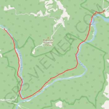
Hike along Little Bluestone River and Bluestone River via Coopers Mill Trail in the Bluestone National Scenic River and the Bluestone State Park. #Hiking #Nature #River #Forest #Park
- Distance: 13.6 Km
- Elevation gain: 316 m
- Maximum elevation: 493 m
- Elevation loss: 319 m
- Minimum elevation: 432 m
- Moving time: 25 m 20 s
- Moving speed: 32.3 Km/h
- Maximum speed: 43.3 Km/h
- Total time: 25 m 20 s
- Global speed: 32.3 Km/h
Interactive trail map
Trail profile
- Distance: 13.6 Km
- Elevation gain: 316 m
- Maximum elevation: 493 m
- Elevation loss: 319 m
- Minimum elevation: 432 m
- Moving time: 25 m 20 s
- Moving speed: 32.3 Km/h
- Maximum speed: 43.3 Km/h
- Total time: 25 m 20 s
- Global speed: 32.3 Km/h
About this trail
Name: Bluestone State Park trail, distance, elevation, map, profile, GPS track
Start: Coopers Mill Trail, Summers County, West Virginia, United States (37.59369 -80.97259)
End: Coopers Mill Trail, Summers County, West Virginia, United States (37.60579 -80.97855)
Coordinates: 37.58370 -80.97855 37.61151 -80.93863
Other hiking, mountain biking, running and outdoor activity trails
Click on a trail to view its statistics, map and profile.
New River Gorge
United States > West Virginia > Mercer County > Athens
Distance: 206.3 Km • Elevation gain: 5,337 m • Maximum elevation: 851 m