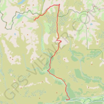
Munro hillwalk Chaorainn Bhreac
Munro, hillwalk, Chaorainn, Bhreac
- Distance: 20.9 Km
- Elevation gain: 625 m
- Maximum elevation: 1,082 m
- Elevation loss: 939 m
- Minimum elevation: 363 m
- Moving time: 4 h 38 m
- Moving speed: 4.5 Km/h
- Maximum speed: 22.3 Km/h
- Total time: 5 h 31 m
- Global speed: 3.8 Km/h
Interactive trail map
Trail profile
- Distance: 20.9 Km
- Elevation gain: 625 m
- Maximum elevation: 1,082 m
- Elevation loss: 939 m
- Minimum elevation: 363 m
- Moving time: 4 h 38 m
- Moving speed: 4.5 Km/h
- Maximum speed: 22.3 Km/h
- Total time: 5 h 31 m
- Global speed: 3.8 Km/h
About this trail
Name: Munro hillwalk Chaorainn Bhreac trail, distance, elevation, map, profile, GPS track
End: Linn of Dee, C1M, Aberdeenshire, Scotland, AB35 5YB, United Kingdom (56.98988 -3.54331)
Coordinates: 56.98915 -3.61044 57.09673 -3.53518
Other hiking, mountain biking, running and outdoor activity trails
Click on a trail to view its statistics, map and profile.
Planned eMTB Gravel: Linn of Dee -> The Red House Bothy - TnB
United Kingdom > Scotland > Aberdeenshire
Following the River Dee west from the Linn of Dee
Distance: 15.2 Km • Elevation gain: 100 m • Maximum elevation: 441 m
Cairngorms hike
United Kingdom > Scotland > Highland > Aviemore
Distance: 80.8 Km • Elevation gain: 3,001 m • Maximum elevation: 1,312 m
Loop eMTB Gravel: Lin of Dee -> Glen Quoich
United Kingdom > Scotland > Aberdeenshire > Claybokie
Distance: 21.2 Km • Elevation gain: 345 m • Maximum elevation: 496 m
Munro hillwalk Mheadhoin Etchachan
United Kingdom > Scotland > Aberdeenshire
Munro, hillwalk, Mheadhoin, Etchachan
Distance: 29.4 Km • Elevation gain: 1,555 m • Maximum elevation: 1,234 m