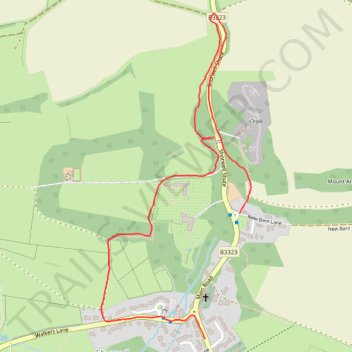
Permissive paths, Shorwell
- Distance: 2.2 Km
- Elevation gain: 78 m
- Maximum elevation: 113 m
- Elevation loss: 72 m
- Minimum elevation: 55 m
- Moving time: 27 m 49 s
- Moving speed: 4.8 Km/h
- Maximum speed: 9.7 Km/h
- Total time: 29 m 31 s
- Global speed: 4.5 Km/h
Interactive trail map
Trail profile
- Distance: 2.2 Km
- Elevation gain: 78 m
- Maximum elevation: 113 m
- Elevation loss: 72 m
- Minimum elevation: 55 m
- Moving time: 27 m 49 s
- Moving speed: 4.8 Km/h
- Maximum speed: 9.7 Km/h
- Total time: 29 m 31 s
- Global speed: 4.5 Km/h
About this trail
Name: Permissive paths, Shorwell trail, distance, elevation, map, profile, GPS track
Start: Farriers Way, Shorwell, Isle of Wight, England, PO30 3LE, United Kingdom (50.64381 -1.35458)
End: New Barn Lane, Shorwell, Isle of Wight, England, PO30 3JQ, United Kingdom (50.64695 -1.35319)
Coordinates: 50.64381 -1.35868 50.65198 -1.35275