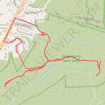
Fond Family Open Space
- Distance: 7.5 Km
- Elevation gain: 327 m
- Maximum elevation: 562 m
- Elevation loss: 326 m
- Minimum elevation: 322 m
- Moving time: 1 h 13 m
- Moving speed: 6.1 Km/h
- Maximum speed: 36.2 Km/h
- Total time: 1 h 22 m
- Global speed: 5.4 Km/h
Interactive trail map
Trail profile
- Distance: 7.5 Km
- Elevation gain: 327 m
- Maximum elevation: 562 m
- Elevation loss: 326 m
- Minimum elevation: 322 m
- Moving time: 1 h 13 m
- Moving speed: 6.1 Km/h
- Maximum speed: 36.2 Km/h
- Total time: 1 h 22 m
- Global speed: 5.4 Km/h
About this trail
Name: Fond Family Open Space trail, distance, elevation, map, profile, GPS track
Coordinates: 34.24294 -118.34673 34.25338 -118.32899
Other hiking, mountain biking, running and outdoor activity trails
Click on a trail to view its statistics, map and profile.
Fond Family Open Space forgotten trail
United States > California > Los Angeles County > Los Angeles
Distance: 6.0 Km • Elevation gain: 302 m • Maximum elevation: 562 m