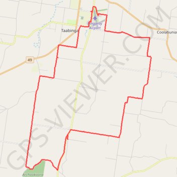
Ushers Hill and Archookoora State Forest loop
- Distance: 52.6 Km
- Elevation gain: 655 m
- Maximum elevation: 563 m
- Elevation loss: 655 m
- Minimum elevation: 379 m
- Moving time: 3 h 2 m
- Moving speed: 17.3 Km/h
- Maximum speed: 61.6 Km/h
- Total time: 3 h 47 m
- Global speed: 13.9 Km/h
Interactive trail map
Trail profile
- Distance: 52.6 Km
- Elevation gain: 655 m
- Maximum elevation: 563 m
- Elevation loss: 655 m
- Minimum elevation: 379 m
- Moving time: 3 h 2 m
- Moving speed: 17.3 Km/h
- Maximum speed: 61.6 Km/h
- Total time: 3 h 47 m
- Global speed: 13.9 Km/h
About this trail
Name: Ushers Hill and Archookoora State Forest loop trail, distance, elevation, map, profile, GPS track
End: Geoff Raph Drive, Taabinga, South Burnett Regional, Queensland, Australia (-26.57704 151.84155)
Coordinates: -26.70405 151.77539 -26.56953 151.89050
Other hiking, mountain biking, running and outdoor activity trails
Click on a trail to view its statistics, map and profile.
Kingaroy Taabinga Boonenne trace
Australia > Queensland > Kingaroy
Loop bike around Kingaroy. #Bike #Loop #Countryside #Nature #Forest
Distance: 36.8 Km • Elevation gain: 368 m • Maximum elevation: 542 m
Goodger to Ellesmere and Archookoora State Forest
Goodger, Brooklands, Ellesmere, Haly Creek, Archookoora, Queensland
Distance: 47.8 Km • Elevation gain: 622 m • Maximum elevation: 551 m
Kingaroy Heights, Usher Hill
Australia > Queensland > Kingaroy
Kingaroy, Coolabunia, Queensland
Distance: 27.2 Km • Elevation gain: 311 m • Maximum elevation: 565 m
Kingaroy to Goodger Queensland
Australia > Queensland > Kingaroy
Goodger, Taabinga, Kingaroy, Boonenne, Queensland
Distance: 38.4 Km • Elevation gain: 300 m • Maximum elevation: 542 m
Kingaroy to Coolabunia and Ushers Hill
Australia > Queensland > Kingaroy
Distance: 39.7 Km • Elevation gain: 459 m • Maximum elevation: 565 m
Memerambi to Ushers Hill
Memerambi, Crawford, Kingaroy, Taabinga, Queensland
Distance: 47.1 Km • Elevation gain: 332 m • Maximum elevation: 567 m
Taabinga and Wattle Grove
Australia > Queensland > Kingaroy
Kingaroy, Taabinga, Inverlaw, Wattle Grove
Distance: 54.3 Km • Elevation gain: 474 m • Maximum elevation: 542 m
Goodger to Nanango
Goodger, Kunioon, Brooklands, South Nanango, Nanango, Barker Creek Flat, Queensland
Distance: 52.0 Km • Elevation gain: 584 m • Maximum elevation: 505 m
Goodger to Ellesmere
Goodger, Brooklands, Ellesmere, Haly Creek, Archookoora, Queensland
Distance: 42.8 Km • Elevation gain: 375 m • Maximum elevation: 615 m
Coolabunia, Ushers Hill
Australia > Queensland > Kingaroy
Distance: 40.1 Km • Elevation gain: 488 m • Maximum elevation: 567 m
Booie loop
Australia > Queensland > Kingaroy
Booie, Kingaroy, Sandy Ridges, Queensland
Distance: 47.7 Km • Elevation gain: 511 m • Maximum elevation: 569 m
Taabinga-Mannuem
Distance: 42.5 Km • Elevation gain: 410 m • Maximum elevation: 546 m