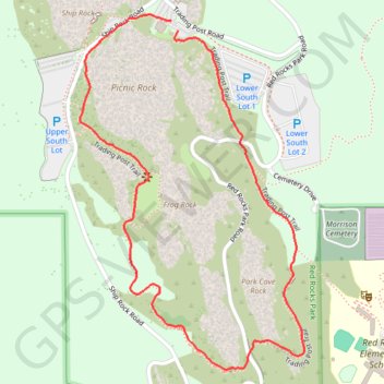
Trading Post Trail in Red Rocks Park
The Trading Post Trail in Red Rocks Park is a delightful loop that showcases the park's breathtaking red rock formations and offers sweeping views of the surrounding landscapes. As you meander along this well-maintained path, you’ll encounter several sets of stairs that add a fun challenge, all while being surrounded by the stunning beauty of the foothills. It’s a perfect short hike for those looking to escape the city and immerse themselves in nature, just a stone's throw from Denver! #Hiking #Loop #Nature #Rock
- Distance: 2.5 Km
- Elevation gain: 110 m
- Maximum elevation: 1,913 m
- Elevation loss: 107 m
- Minimum elevation: 1,802 m
- Moving time: 53 m 29 s
- Moving speed: 2.8 Km/h
- Maximum speed: 5.8 Km/h
- Total time: 59 m 2 s
- Global speed: 2.6 Km/h
Interactive trail map
Trail profile
- Distance: 2.5 Km
- Elevation gain: 110 m
- Maximum elevation: 1,913 m
- Elevation loss: 107 m
- Minimum elevation: 1,802 m
- Moving time: 53 m 29 s
- Moving speed: 2.8 Km/h
- Maximum speed: 5.8 Km/h
- Total time: 59 m 2 s
- Global speed: 2.6 Km/h
About this trail
Name: Trading Post Trail in Red Rocks Park trail, distance, elevation, map, profile, GPS track
Start: Trading Post Trail, Jefferson County, Colorado, 80465, United States (39.66385 -105.20256)
Coordinates: 39.65660 -105.20529 39.66420 -105.19905
Other hiking, mountain biking, running and outdoor activity trails
Click on a trail to view its statistics, map and profile.
Mount Morrison Trail in Matthews/Winters Park
United States > Colorado > Jefferson County
The Mount Morrison Trail offers a rigorous climb through scenic terrain, providing hikers with expansive views of the surrounding Colorado landscape, including the iconic Red Rocks formations, the distant cityscape of Denver, and the rugged peaks of the Front Range. As you ascend, the trail showcases dramatic…
Distance: 5.9 Km • Elevation gain: 625 m • Maximum elevation: 2,393 m