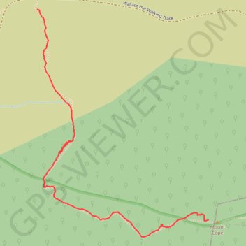
Ski Up to Mount Cope
Mount Cope Ski Track
- Distance: 1.8 Km
- Elevation gain: 134 m
- Maximum elevation: 1,816 m
- Elevation loss: 4 m
- Minimum elevation: 1,686 m
- Moving time: 36 m
- Moving speed: 3.1 Km/h
- Maximum speed: 10.2 Km/h
- Total time: 1 h 10 m
- Global speed: 1.6 Km/h
Interactive trail map
Trail profile
- Distance: 1.8 Km
- Elevation gain: 134 m
- Maximum elevation: 1,816 m
- Elevation loss: 4 m
- Minimum elevation: 1,686 m
- Moving time: 36 m
- Moving speed: 3.1 Km/h
- Maximum speed: 10.2 Km/h
- Total time: 1 h 10 m
- Global speed: 1.6 Km/h
About this trail
Name: Ski Up to Mount Cope trail, distance, elevation, map, profile, GPS track
Coordinates: -36.92762 147.27306 -36.91946 147.28074
Other hiking, mountain biking, running and outdoor activity trails
Click on a trail to view its statistics, map and profile.
Cope Hut to Mount Jaithmatang and Tawanga Huts in Autralian Alps
Distance: 15.0 Km • Elevation gain: 395 m • Maximum elevation: 1,826 m