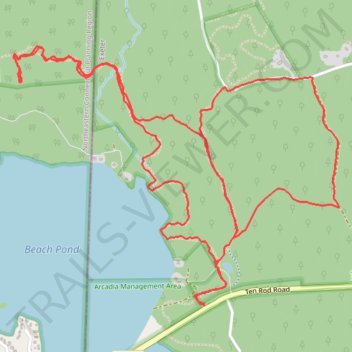
Arcadia - East of Beach Pond loop
- Distance: 8.7 Km
- Elevation gain: 128 m
- Maximum elevation: 163 m
- Elevation loss: 128 m
- Minimum elevation: 93 m
- Moving time: 2 h 3 m
- Moving speed: 4.2 Km/h
- Maximum speed: 6.7 Km/h
- Total time: 2 h 44 m
- Global speed: 3.2 Km/h
Interactive trail map
Trail profile
- Distance: 8.7 Km
- Elevation gain: 128 m
- Maximum elevation: 163 m
- Elevation loss: 128 m
- Minimum elevation: 93 m
- Moving time: 2 h 3 m
- Moving speed: 4.2 Km/h
- Maximum speed: 6.7 Km/h
- Total time: 2 h 44 m
- Global speed: 3.2 Km/h
About this trail
Name: Arcadia - East of Beach Pond loop trail, distance, elevation, map, profile, GPS track
Start: 2857, Ten Rod Road, Exeter, South County, Rhode Island, 02822, United States (41.57540 -71.78298)
End: 2857, Ten Rod Road, Exeter, South County, Rhode Island, 02822, United States (41.57537 -71.78300)
Coordinates: 41.57537 -71.79477 41.58728 -71.77471