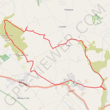
Breage - Tregonning Hill Loop
- Distance: 9.9 Km
- Elevation gain: 207 m
- Maximum elevation: 194 m
- Elevation loss: 208 m
- Minimum elevation: 33 m
- Moving time: 2 h 22 m
- Moving speed: 4.2 Km/h
- Maximum speed: 6.5 Km/h
- Total time: 2 h 34 m
- Global speed: 3.8 Km/h
Interactive trail map
Trail profile
- Distance: 9.9 Km
- Elevation gain: 207 m
- Maximum elevation: 194 m
- Elevation loss: 208 m
- Minimum elevation: 33 m
- Moving time: 2 h 22 m
- Moving speed: 4.2 Km/h
- Maximum speed: 6.5 Km/h
- Total time: 2 h 34 m
- Global speed: 3.8 Km/h
About this trail
Name: Breage - Tregonning Hill Loop trail, distance, elevation, map, profile, GPS track
Start: Breage, Cornwall, England, TR13 9PW, United Kingdom (50.10866 -5.33160)
End: Sethnoe Way, Breage, Cornwall, England, TR13 9PE, United Kingdom (50.10850 -5.33111)
Coordinates: 50.10657 -5.36095 50.12525 -5.31847