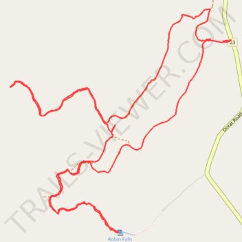
Robin Falls Trail
- Distance: 11.8 Km
- Elevation gain: 339 m
- Maximum elevation: 216 m
- Elevation loss: 337 m
- Minimum elevation: 73 m
- Moving time: 1 h 34 m
- Moving speed: 7.5 Km/h
- Maximum speed: 12.3 Km/h
- Total time: 2 h 12 m
- Global speed: 5.3 Km/h
Interactive trail map
Trail profile
- Distance: 11.8 Km
- Elevation gain: 339 m
- Maximum elevation: 216 m
- Elevation loss: 337 m
- Minimum elevation: 73 m
- Moving time: 1 h 34 m
- Moving speed: 7.5 Km/h
- Maximum speed: 12.3 Km/h
- Total time: 2 h 12 m
- Global speed: 5.3 Km/h
About this trail
Name: Robin Falls Trail trail, distance, elevation, map, profile, GPS track
Start: Robin Falls, Coomalie Shire, Northern Territory, Australia (-13.33772 131.13905)
End: Robin Falls, Coomalie Shire, Northern Territory, Australia (-13.33758 131.13798)
Coordinates: -13.35444 131.12005 -13.33494 131.13981
Other hiking, mountain biking, running and outdoor activity trails
Click on a trail to view its statistics, map and profile.
Adelaide River - Robin Falls
Australia > Coomalie Shire > Adelaide River > Amangal
Distance: 19.4 Km • Elevation gain: 371 m • Maximum elevation: 215 m