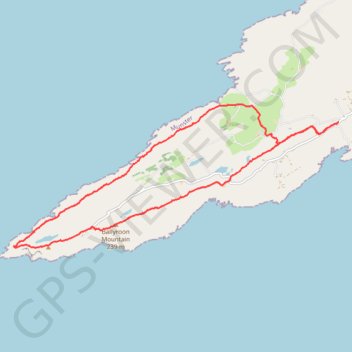
Ballyroon Mountain - Sheep's Head
Interactive trail map
Trail profile
- Distance: 15.5 Km
- Elevation gain: 532 m
- Maximum elevation: 232 m
- Elevation loss: 533 m
- Minimum elevation: 11 m
About this trail
Name: Ballyroon Mountain - Sheep's Head trail, distance, elevation, map, profile, GPS track
Start: Sheepshead, West Cork, County Cork, Munster, Ireland (51.56386 -9.75860)
End: Sheepshead, West Cork, County Cork, Munster, Ireland (51.56390 -9.75845)
Coordinates: 51.54250 -9.84770 51.56698 -9.75845