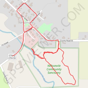
Nelsonville Walk Loop
Loop walk / hike in Nelsonville via Nelsonville Community Sanctuary and Tomorrow River. #Walking #Hiking #Loop #Nature #Park #Forest #River
- Distance: 3.1 Km
- Elevation gain: 38 m
- Maximum elevation: 337 m
- Elevation loss: 47 m
- Minimum elevation: 320 m
- Moving time: 28 m 19 s
- Moving speed: 6.6 Km/h
- Maximum speed: 48.5 Km/h
- Total time: 32 m 7 s
- Global speed: 5.8 Km/h
Interactive trail map
Trail profile
- Distance: 3.1 Km
- Elevation gain: 38 m
- Maximum elevation: 337 m
- Elevation loss: 47 m
- Minimum elevation: 320 m
- Moving time: 28 m 19 s
- Moving speed: 6.6 Km/h
- Maximum speed: 48.5 Km/h
- Total time: 32 m 7 s
- Global speed: 5.8 Km/h
About this trail
Name: Nelsonville Walk Loop trail, distance, elevation, map, profile, GPS track
End: CTH Q;CTH SS, Nelsonville, Portage County, Wisconsin, 54945, United States (44.49266 -89.31169)
Coordinates: 44.49040 -89.31169 44.49683 -89.30472