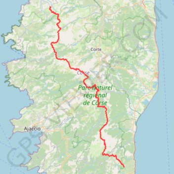
00. GR 20 - Sud - Nord on GPSies.com
00. GR 20 - Sud - Nord
- Distance: 176.1 Km
- Elevation gain: 12,910 m
- Maximum elevation: 2,243 m
- Elevation loss: 12,883 m
- Minimum elevation: 249 m
- Moving time: 17 h 16 m
- Moving speed: 10.2 Km/h
- Maximum speed: 14.1 Km/h
- Total time: 17 h 16 m
- Global speed: 10.2 Km/h
Interactive trail map
Trail profile
- Distance: 176.1 Km
- Elevation gain: 12,910 m
- Maximum elevation: 2,243 m
- Elevation loss: 12,883 m
- Minimum elevation: 249 m
- Moving time: 17 h 16 m
- Moving speed: 10.2 Km/h
- Maximum speed: 14.1 Km/h
- Total time: 17 h 16 m
- Global speed: 10.2 Km/h
About this trail
Name: 00. GR 20 - Sud - Nord on GPSies.com trail, distance, elevation, map, profile, GPS track
Coordinates: 41.73474 8.84968 42.50825 9.33398
Other hiking, mountain biking, running and outdoor activity trails
Click on a trail to view its statistics, map and profile.
1 LUCENA - MONTPELLIER
Distance: 2,964.4 Km • Elevation gain: 29,500 m • Maximum elevation: 1,048 m
Etang de Gialicatapiano depuis le Verghello
France > Corsica > Haute-Corse > Venaco
Distance: 16.8 Km • Elevation gain: 1,486 m • Maximum elevation: 1,892 m
New
France > Corsica > Haute-Corse > Monticello
Distance: 50.0 Km • Elevation gain: 1,023 m • Maximum elevation: 536 m