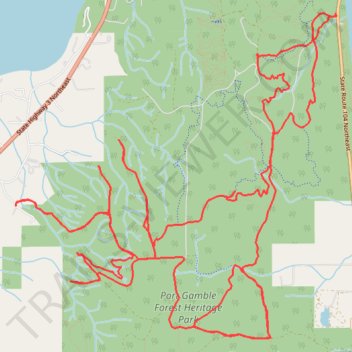
Port Gamble Forest Heritage Park Mountain Biking
- Distance: 24.0 Km
- Elevation gain: 569 m
- Maximum elevation: 144 m
- Elevation loss: 570 m
- Minimum elevation: 17 m
- Moving time: 2 h 21 m
- Moving speed: 10.1 Km/h
- Maximum speed: 36.2 Km/h
- Total time: 2 h 32 m
- Global speed: 9.4 Km/h
Interactive trail map
Trail profile
- Distance: 24.0 Km
- Elevation gain: 569 m
- Maximum elevation: 144 m
- Elevation loss: 570 m
- Minimum elevation: 17 m
- Moving time: 2 h 21 m
- Moving speed: 10.1 Km/h
- Maximum speed: 36.2 Km/h
- Total time: 2 h 32 m
- Global speed: 9.4 Km/h
About this trail
Name: Port Gamble Forest Heritage Park Mountain Biking trail, distance, elevation, map, profile, GPS track
Coordinates: 47.81241 -122.62851 47.84033 -122.58758
Other hiking, mountain biking, running and outdoor activity trails
Click on a trail to view its statistics, map and profile.
Port Gamble Forest Heritage Park Loop MTB
United States > Washington > Kitsap County > Port Gamble
Distance: 16.7 Km • Elevation gain: 292 m • Maximum elevation: 143 m