Ballinastoe Wood Loop MTB
- Distance: 11.6 Km
- Elevation gain: 336 m
- Maximum elevation: 502 m
- Elevation loss: 345 m
- Minimum elevation: 321 m
- Moving time: 1 h 16 m
- Moving speed: 9.1 Km/h
- Maximum speed: 39.6 Km/h
- Total time: 2 h 3 m
- Global speed: 5.6 Km/h
Interactive trail map
Trail profile
- Distance: 11.6 Km
- Elevation gain: 336 m
- Maximum elevation: 502 m
- Elevation loss: 345 m
- Minimum elevation: 321 m
- Moving time: 1 h 16 m
- Moving speed: 9.1 Km/h
- Maximum speed: 39.6 Km/h
- Total time: 2 h 3 m
- Global speed: 5.6 Km/h
About this trail
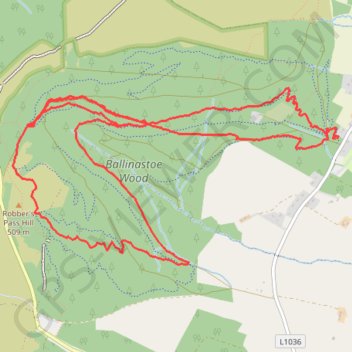
Name: Ballinastoe Wood Loop MTB trail, distance, elevation, map, profile, GPS track
Coordinates: 53.09939 -6.25349 53.11119 -6.21726
Other hiking, mountain biking, running and outdoor activity trails
Click on a trail to view its statistics, map and profile.
Ballinastoe Wood Loop MTB
Distance: 11.4 Km • Elevation gain: 325 m • Maximum elevation: 483 m
Ballinastoe Wood MTB Loop
Distance: 14.7 Km • Elevation gain: 512 m • Maximum elevation: 555 m
Ballinastoe MTB
Distance: 13.1 Km • Elevation gain: 376 m • Maximum elevation: 502 m
White Hill Hike
Distance: 4.5 Km • Elevation gain: 160 m • Maximum elevation: 628 m