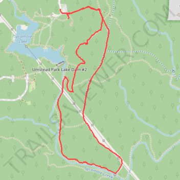
Sycamore and Graylyn Loop at Umstead Park
- Distance: 5.1 Km
- Elevation gain: 85 m
- Maximum elevation: 143 m
- Elevation loss: 83 m
- Minimum elevation: 91 m
- Moving time: 1 h 9 m
- Moving speed: 4.4 Km/h
- Maximum speed: 7.3 Km/h
- Total time: 1 h 14 m
- Global speed: 4.1 Km/h
Interactive trail map
Trail profile
- Distance: 5.1 Km
- Elevation gain: 85 m
- Maximum elevation: 143 m
- Elevation loss: 83 m
- Minimum elevation: 91 m
- Moving time: 1 h 9 m
- Moving speed: 4.4 Km/h
- Maximum speed: 7.3 Km/h
- Total time: 1 h 14 m
- Global speed: 4.1 Km/h
About this trail
Name: Sycamore and Graylyn Loop at Umstead Park trail, distance, elevation, map, profile, GPS track
Start: Sycamore Trail, Raleigh, Wake County, North Carolina, 27617, United States (35.86754 -78.75256)
End: Sycamore Trail, Raleigh, Wake County, North Carolina, 27617, United States (35.86720 -78.75191)
Coordinates: 35.85395 -78.75279 35.86773 -78.74625
Other hiking, mountain biking, running and outdoor activity trails
Click on a trail to view its statistics, map and profile.
Company Mill Loop Trail in William B. Umstead State Park
United States > North Carolina > Wake County > Raleigh
The Company Mill Loop Trail weaves through picturesque hardwood forests, hugging the banks of Crabtree Creek before ascending into quiet ridges. Hikers can enjoy a blend of open creekside views, where remnants of an old mill create a peaceful spot to rest, and more secluded sections under a canopy of pines and…
Distance: 10.0 Km • Elevation gain: 183 m • Maximum elevation: 143 m