Thank you for supporting this site ❤️
Make a donation
Make a donation
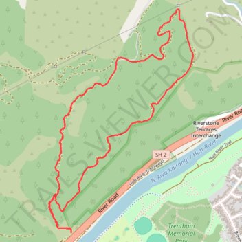
2026-01-25_10-13_Sun
- Distance: 5.0 Km
- Elevation gain: 231 m
- Maximum elevation: 207 m
- Elevation loss: 221 m
- Minimum elevation: 45 m
- Moving time: 56 m 31 s
- Moving speed: 5.3 Km/h
- Maximum speed: 16.2 Km/h
- Total time: 57 m 55 s
- Global speed: 5.1 Km/h
Interactive trail map
Thank you for supporting this site ❤️
Make a donation
Make a donation
Trail profile
- Distance: 5.0 Km
- Elevation gain: 231 m
- Maximum elevation: 207 m
- Elevation loss: 221 m
- Minimum elevation: 45 m
- Moving time: 56 m 31 s
- Moving speed: 5.3 Km/h
- Maximum speed: 16.2 Km/h
- Total time: 57 m 55 s
- Global speed: 5.1 Km/h
Thank you for supporting this site ❤️
Make a donation
Make a donation
About this trail
Name: 2026-01-25_10-13_Sun trail, distance, elevation, map, profile, GPS track
Coordinates: -41.13151 175.01799 -41.11772 175.02975
Thank you for supporting this site ❤️
Make a donation
Make a donation
Other hiking, mountain biking, running and outdoor activity trails
Click on a trail to view its statistics, map and profile.
2023-07-13_14-57_Thu
New Zealand > Wellington > Upper Hutt City > Upper Hutt
Distance: 5.1 Km • Elevation gain: 221 m • Maximum elevation: 206 m