Jones Peak
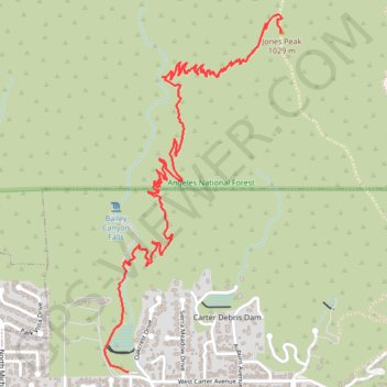
Interactive trail map
Trail profile
- Distance: 5.2 Km
- Elevation gain: 804 m
- Maximum elevation: 1,004 m
- Elevation loss: 141 m
- Minimum elevation: 340 m
About this trail
Name: Jones Peak trail, distance, elevation, map, profile, GPS track
Coordinates: 34.17103 -118.06253 34.18731 -118.05277
Other hiking, mountain biking, running and outdoor activity trails
Click on a trail to view its statistics, map and profile.
Mount Wilson Trail in Angeles National Forest
United States > California > Los Angeles County > Sierra Madre
The Mount Wilson Trail in the Angeles National Forest offers hikers a challenging ascent through diverse ecosystems, including shaded woodlands and rugged canyons. Along the route, one can observe the historic ruins of Orchard Camp, a popular resort from the 1890s to the 1930s. Upon reaching the summit, hikers…
Distance: 23.0 Km • Elevation gain: 1,829 m • Maximum elevation: 1,726 m