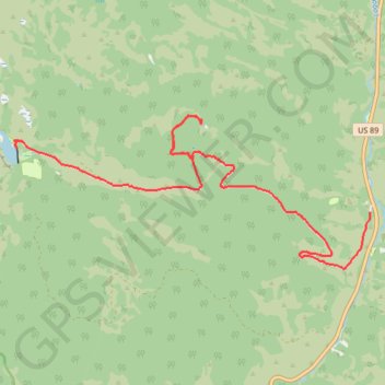
Tony Grove Lake
- Distance: 14.6 Km
- Elevation gain: 676 m
- Maximum elevation: 2,457 m
- Elevation loss: 127 m
- Minimum elevation: 1,904 m
- Moving time: 1 h 21 m
- Moving speed: 10.7 Km/h
- Maximum speed: 44.5 Km/h
- Total time: 1 h 29 m
- Global speed: 9.8 Km/h
Interactive trail map
Trail profile
- Distance: 14.6 Km
- Elevation gain: 676 m
- Maximum elevation: 2,457 m
- Elevation loss: 127 m
- Minimum elevation: 1,904 m
- Moving time: 1 h 21 m
- Moving speed: 10.7 Km/h
- Maximum speed: 44.5 Km/h
- Total time: 1 h 29 m
- Global speed: 9.8 Km/h
About this trail
Name: Tony Grove Lake trail, distance, elevation, map, profile, GPS track
Start: Tony Grove Road, Cache County, Utah, United States (41.88336 -111.56428)
End: Tony Grove Road, Cache County, Utah, United States (41.89496 -111.64123)
Coordinates: 41.87402 -111.64251 41.89908 -111.56428