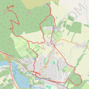
EMTB Gravel: Pitlochry Highlights - Loop
- Distance: 16.3 Km
- Elevation gain: 559 m
- Maximum elevation: 449 m
- Elevation loss: 556 m
- Minimum elevation: 98 m
- Moving time: 2 h 11 s
- Moving speed: 8.1 Km/h
- Maximum speed: 34.3 Km/h
- Total time: 2 h 29 m
- Global speed: 6.5 Km/h
Interactive trail map
Trail profile
- Distance: 16.3 Km
- Elevation gain: 559 m
- Maximum elevation: 449 m
- Elevation loss: 556 m
- Minimum elevation: 98 m
- Moving time: 2 h 11 s
- Moving speed: 8.1 Km/h
- Maximum speed: 34.3 Km/h
- Total time: 2 h 29 m
- Global speed: 6.5 Km/h
About this trail
Name: EMTB Gravel: Pitlochry Highlights - Loop trail, distance, elevation, map, profile, GPS track
Coordinates: 56.69957 -3.75402 56.72643 -3.70977
Other hiking, mountain biking, running and outdoor activity trails
Click on a trail to view its statistics, map and profile.
Loop hillwalk to Ben Vrackie and Meall an Daimh from Moulin Pitlochry
United Kingdom > Scotland > Perth and Kinross > Moulin > Balnakeilly
Distance: 12.3 Km • Elevation gain: 809 m • Maximum elevation: 833 m
Dunfallandy Hill Loop via An Suidhe
United Kingdom > Scotland > Perth and Kinross > Pitlochry
eMTB Gravel - Pitlochry ‘Escape Route’ Cafe -> Dunfallandy Stone - Loop
Distance: 20.4 Km • Elevation gain: 529 m • Maximum elevation: 404 m
EMTB Gravel: Loch a' Choire loop
United Kingdom > Scotland > Perth and Kinross > Moulin > Balnakeilly
To Loch a' Choire beneath Ben Vrackie #UK #Perthshire #Pitlochry
Distance: 6.7 Km • Elevation gain: 310 m • Maximum elevation: 534 m
Loch Tummel Loop
United Kingdom > Scotland > Perth and Kinross > Pitlochry
To Escape Route Cafe UK, Perthshire, Loch Tummel
Distance: 46.3 Km • Elevation gain: 819 m • Maximum elevation: 289 m