Thank you for supporting this site ❤️
Make a donation
Make a donation
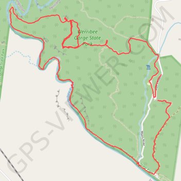
Werribee Gorge State Park Loop
Interactive trail map
Thank you for supporting this site ❤️
Make a donation
Make a donation
Trail profile
- Distance: 9.3 Km
- Elevation gain: 431 m
- Maximum elevation: 345 m
- Elevation loss: 406 m
- Minimum elevation: 139 m
- Moving time: 2 h 3 m
- Moving speed: 4.5 Km/h
- Maximum speed: 43.5 Km/h
- Total time: 2 h 23 m
- Global speed: 3.9 Km/h
Thank you for supporting this site ❤️
Make a donation
Make a donation
About this trail
Name: Werribee Gorge State Park Loop trail, distance, elevation, map, profile, GPS track
End: Myers Road, Pentland Hills, Shire of Moorabool, Victoria, 3341, Australia (-37.66306 144.36482)
Coordinates: -37.67296 144.34583 -37.65633 144.36606
Thank you for supporting this site ❤️
Make a donation
Make a donation
Other hiking, mountain biking, running and outdoor activity trails
Click on a trail to view its statistics, map and profile.