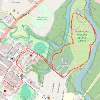
North Coast Regional Botanic Garden loop
Lunch Run
- Distance: 6.4 Km
- Elevation gain: 33 m
- Maximum elevation: 11 m
- Elevation loss: 33 m
- Minimum elevation: 2 m
- Moving time: 40 m 18 s
- Moving speed: 9.5 Km/h
- Maximum speed: 22.6 Km/h
- Total time: 46 m 25 s
- Global speed: 8.2 Km/h
Interactive trail map
Trail profile
- Distance: 6.4 Km
- Elevation gain: 33 m
- Maximum elevation: 11 m
- Elevation loss: 33 m
- Minimum elevation: 2 m
- Moving time: 40 m 18 s
- Moving speed: 9.5 Km/h
- Maximum speed: 22.6 Km/h
- Total time: 46 m 25 s
- Global speed: 8.2 Km/h
About this trail
Name: North Coast Regional Botanic Garden loop trail, distance, elevation, map, profile, GPS track
Coordinates: -30.29984 153.11571 -30.29189 153.12717
Other hiking, mountain biking, running and outdoor activity trails
Click on a trail to view its statistics, map and profile.
Coffs Creek Walk and Cycleway
Australia > New South Wales > Coffs Harbour
Morning Run
Distance: 6.7 Km • Elevation gain: 36 m • Maximum elevation: 12 m