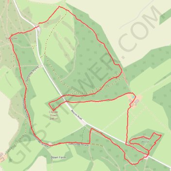
Ivinghoe Beacon
- Distance: 8.2 Km
- Elevation gain: 148 m
- Maximum elevation: 251 m
- Elevation loss: 146 m
- Minimum elevation: 166 m
- Moving time: 1 h 13 m
- Moving speed: 6.8 Km/h
- Maximum speed: 20.1 Km/h
- Total time: 1 h 18 m
- Global speed: 6.3 Km/h
Interactive trail map
Trail profile
- Distance: 8.2 Km
- Elevation gain: 148 m
- Maximum elevation: 251 m
- Elevation loss: 146 m
- Minimum elevation: 166 m
- Moving time: 1 h 13 m
- Moving speed: 6.8 Km/h
- Maximum speed: 20.1 Km/h
- Total time: 1 h 18 m
- Global speed: 6.3 Km/h
About this trail
Name: Ivinghoe Beacon trail, distance, elevation, map, profile, GPS track
Coordinates: 51.82112 -0.60741 51.83604 -0.58430
Other hiking, mountain biking, running and outdoor activity trails
Click on a trail to view its statistics, map and profile.
The Jo Cox Way 2022 Day 4 - Milton Keynes to Uxbridge
United Kingdom > England > City of Milton Keynes > Milton Keynes > Monkston
Distance: 104.4 Km • Elevation gain: 1,038 m • Maximum elevation: 251 m
The JCW 23 - Cranfield to Uxbridge
United Kingdom > England > Central Bedfordshire > Cranfield
Distance: 90.1 Km • Elevation gain: 863 m • Maximum elevation: 266 m
Dockey Woods
United Kingdom > England > Buckinghamshire > Ivinghoe
Distance: 9.7 Km • Elevation gain: 150 m • Maximum elevation: 251 m
JCW25 Day 4
United Kingdom > England > Central Bedfordshire > Cranfield
Distance: 105.9 Km • Elevation gain: 965 m • Maximum elevation: 266 m