Black Mountain - Cabin Lake - Sam Lake - Theagill Lake
Cypress Provincial Park. #Hiking #Snowshoeing #Ski #Loop #Cypress
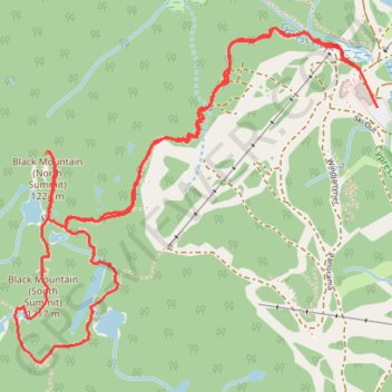
- Distance: 5.4 Km
- Elevation gain: 336 m
- Maximum elevation: 1,205 m
- Elevation loss: 336 m
- Minimum elevation: 916 m
Interactive trail map
Trail profile
- Distance: 5.4 Km
- Elevation gain: 336 m
- Maximum elevation: 1,205 m
- Elevation loss: 336 m
- Minimum elevation: 916 m
About this trail
Name: Black Mountain - Cabin Lake - Sam Lake - Theagill Lake trail, distance, elevation, map, profile, GPS track
Coordinates: 49.38816 -123.22018 49.39787 -123.20404
Other hiking, mountain biking, running and outdoor activity trails
Click on a trail to view its statistics, map and profile.
Saint Marks Summit
Canada > British Columbia > Metro Vancouver Regional District > West Vancouver
Cypress Provincial Park. #Hiking #SaintMarks #Cypress
Distance: 12.1 Km • Elevation gain: 807 m • Maximum elevation: 1,335 m
Eagleridge Bluffs - Cabin Lake - Black Mountain
Canada > British Columbia > Metro Vancouver Regional District > West Vancouver
Cypress Provincial Park. #Hiking #Snowshoeing #Loop
Distance: 8.8 Km • Elevation gain: 458 m • Maximum elevation: 1,191 m