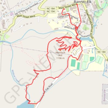
Wildcat Lake and Hemlock Hill Loop
Starting in Banner Elk, the loop heads out through town to Mill Pond, where calm water and a pleasant valley setting introduce the walk before the route turns toward the grounds of Lees-McRae College.
From there, the itinerary continues across the college area and down to Wildcat Lake, a scenic lakeside section framed by wooded slopes and open views that gives the outing one of its most relaxing highlights.
The final part climbs and circles around Hemlock Hill through forested trails and hillside terrain, then returns toward Banner Elk to complete a varied loop combining village streets, campus paths, lake scenery and quiet woodland.
#Hiking #Loop #Nature #Forest #Lake #Mountain #Pond
- Distance: 7.5 Km
- Elevation gain: 209 m
- Maximum elevation: 1,180 m
- Elevation loss: 212 m
- Minimum elevation: 1,108 m
- Moving time: 1 h 47 m
- Moving speed: 4.2 Km/h
- Maximum speed: 6.6 Km/h
- Total time: 2 h 9 m
- Global speed: 3.5 Km/h
Interactive trail map
Trail profile
- Distance: 7.5 Km
- Elevation gain: 209 m
- Maximum elevation: 1,180 m
- Elevation loss: 212 m
- Minimum elevation: 1,108 m
- Moving time: 1 h 47 m
- Moving speed: 4.2 Km/h
- Maximum speed: 6.6 Km/h
- Total time: 2 h 9 m
- Global speed: 3.5 Km/h
About this trail
Name: Wildcat Lake and Hemlock Hill Loop trail, distance, elevation, map, profile, GPS track
Coordinates: 36.14833 -81.88222 36.16300 -81.87197