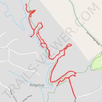
Ridgetop Horse trails
- Distance: 9.8 Km
- Elevation gain: 157 m
- Maximum elevation: 493 m
- Elevation loss: 157 m
- Minimum elevation: 467 m
- Moving time: 2 h 3 m
- Moving speed: 4.8 Km/h
- Maximum speed: 13.1 Km/h
- Total time: 6 h 11 m
- Global speed: 1.6 Km/h
Interactive trail map
Trail profile
- Distance: 9.8 Km
- Elevation gain: 157 m
- Maximum elevation: 493 m
- Elevation loss: 157 m
- Minimum elevation: 467 m
- Moving time: 2 h 3 m
- Moving speed: 4.8 Km/h
- Maximum speed: 13.1 Km/h
- Total time: 6 h 11 m
- Global speed: 1.6 Km/h
About this trail
Name: Ridgetop Horse trails trail, distance, elevation, map, profile, GPS track
Start: Private, Ridgetop, Fentress County, Middle Tennessee, Tennessee, United States (36.45051 -84.84040)
End: Private, Ridgetop, Fentress County, Middle Tennessee, Tennessee, United States (36.45053 -84.84040)
Coordinates: 36.45042 -84.84890 36.46334 -84.84030