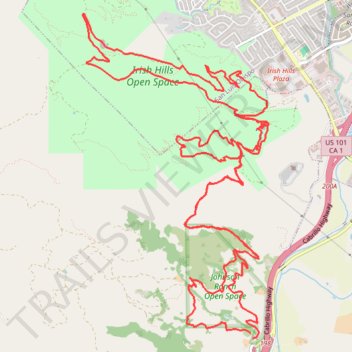
Johnson Ranch Open Space and Irish Hills Open Space loop
- Distance: 24.8 Km
- Elevation gain: 761 m
- Maximum elevation: 261 m
- Elevation loss: 763 m
- Minimum elevation: 29 m
- Moving time: 3 h 12 m
- Moving speed: 7.7 Km/h
- Maximum speed: 34.3 Km/h
- Total time: 4 h 24 m
- Global speed: 5.6 Km/h
Interactive trail map
Trail profile
- Distance: 24.8 Km
- Elevation gain: 761 m
- Maximum elevation: 261 m
- Elevation loss: 763 m
- Minimum elevation: 29 m
- Moving time: 3 h 12 m
- Moving speed: 7.7 Km/h
- Maximum speed: 34.3 Km/h
- Total time: 4 h 24 m
- Global speed: 5.6 Km/h
About this trail
Name: Johnson Ranch Open Space and Irish Hills Open Space loop trail, distance, elevation, map, profile, GPS track
Start: Johnson Ranch Loop, San Luis Obispo County, California, 93405, United States (35.22446 -120.69358)
End: Johnson Ranch Loop, San Luis Obispo County, California, 93405, United States (35.22392 -120.69331)
Coordinates: 35.22392 -120.71513 35.25800 -120.69120