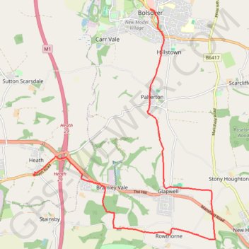
Heath to Bolsover
- Distance: 13.5 Km
- Elevation gain: 170 m
- Maximum elevation: 181 m
- Elevation loss: 144 m
- Minimum elevation: 89 m
- Moving time: 3 h 25 m
- Moving speed: 3.9 Km/h
- Maximum speed: 8.1 Km/h
- Total time: 4 h 11 m
- Global speed: 3.2 Km/h
Interactive trail map
Trail profile
- Distance: 13.5 Km
- Elevation gain: 170 m
- Maximum elevation: 181 m
- Elevation loss: 144 m
- Minimum elevation: 89 m
- Moving time: 3 h 25 m
- Moving speed: 3.9 Km/h
- Maximum speed: 8.1 Km/h
- Total time: 4 h 11 m
- Global speed: 3.2 Km/h
About this trail
Name: Heath to Bolsover trail, distance, elevation, map, profile, GPS track
Coordinates: 53.17950 -1.33340 53.22942 -1.26766
Other hiking, mountain biking, running and outdoor activity trails
Click on a trail to view its statistics, map and profile.
RE SK490680
United Kingdom > England > Derbyshire > Bolsover > Scarcliffe
Distance: 3.3 Km • Elevation gain: 31 m • Maximum elevation: 164 m