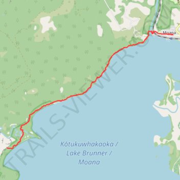
Lake Brunner Scenic Trail
- Distance: 19.4 Km
- Elevation gain: 188 m
- Maximum elevation: 112 m
- Elevation loss: 189 m
- Minimum elevation: 89 m
- Moving time: 1 h 24 m
- Moving speed: 13.8 Km/h
- Maximum speed: 27.9 Km/h
- Total time: 1 h 47 m
- Global speed: 10.8 Km/h
Interactive trail map
Trail profile
- Distance: 19.4 Km
- Elevation gain: 188 m
- Maximum elevation: 112 m
- Elevation loss: 189 m
- Minimum elevation: 89 m
- Moving time: 1 h 24 m
- Moving speed: 13.8 Km/h
- Maximum speed: 27.9 Km/h
- Total time: 1 h 47 m
- Global speed: 10.8 Km/h
About this trail
Name: Lake Brunner Scenic Trail trail, distance, elevation, map, profile, GPS track
Start: 27, Ahau Street, Moana, Grey District, West Coast, 7845, New Zealand (-42.57564 171.47954)
End: 34, Ahau Street, Moana, Grey District, West Coast, 7845, New Zealand (-42.57567 171.47918)
Coordinates: -42.61494 171.40162 -42.57443 171.47954
Other hiking, mountain biking, running and outdoor activity trails
Click on a trail to view its statistics, map and profile.