Sol Duc Falls
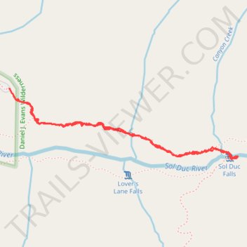
Interactive trail map
Trail profile
- Distance: 3.0 Km
- Elevation gain: 93 m
- Maximum elevation: 634 m
- Elevation loss: 92 m
- Minimum elevation: 591 m
- Moving time: 45 m 41 s
- Moving speed: 3.9 Km/h
- Maximum speed: 20.2 Km/h
- Total time: 48 m 10 s
- Global speed: 3.7 Km/h
About this trail
Name: Sol Duc Falls trail, distance, elevation, map, profile, GPS track
Start: Sol Duc Falls Nature Trail, Clallam County, Washington, United States (47.95467 -123.83460)
Coordinates: 47.95167 -123.83480 47.95490 -123.81928
Other hiking, mountain biking, running and outdoor activity trails
Click on a trail to view its statistics, map and profile.
Sol Duc Falls Trail in Olympic National Park
United States > Washington > Clallam County
The Sol Duc Falls Trail in Olympic National Park offers an enchanting journey through lush, moss-draped old-growth forests, leading to the stunning Sol Duc Falls, where water cascades gracefully into a narrow gorge. Along the well-maintained path, hikers traverse charming wooden bridges over clear streams and…
Distance: 2.8 Km • Elevation gain: 83 m • Maximum elevation: 635 m
Deer Lake Trail via Sol Duc Falls
United States > Washington > Clallam County
Distance: 4.0 Km • Elevation gain: 369 m • Maximum elevation: 930 m