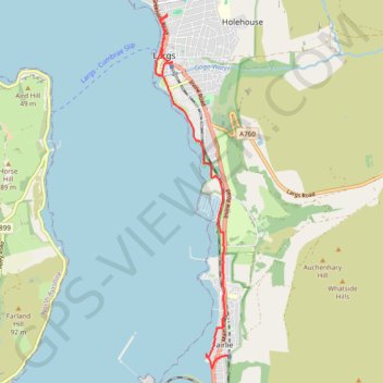
Fairlie to Largs Walk
Clyde Muirshiel Regional Park
- Distance: 9.2 Km
- Elevation gain: 47 m
- Maximum elevation: 16 m
- Elevation loss: 61 m
- Minimum elevation: 0 m
- Moving time: 2 h 46 m
- Moving speed: 3.3 Km/h
- Maximum speed: 8.9 Km/h
- Total time: 5 h 37 m
- Global speed: 1.6 Km/h
Interactive trail map
Trail profile
- Distance: 9.2 Km
- Elevation gain: 47 m
- Maximum elevation: 16 m
- Elevation loss: 61 m
- Minimum elevation: 0 m
- Moving time: 2 h 46 m
- Moving speed: 3.3 Km/h
- Maximum speed: 8.9 Km/h
- Total time: 5 h 37 m
- Global speed: 1.6 Km/h
About this trail
Name: Fairlie to Largs Walk trail, distance, elevation, map, profile, GPS track
Start: Station Road, Fairlie, North Ayrshire, Scotland, KA29 0DX, United Kingdom (55.75199 -4.85342)
Coordinates: 55.75023 -4.87165 55.80070 -4.85342
Other hiking, mountain biking, running and outdoor activity trails
Click on a trail to view its statistics, map and profile.
Irvine, Scotland to Largs and back
United Kingdom > Scotland > North Ayrshire > Irvine
Morning Bike Ride
Distance: 66.9 Km • Elevation gain: 324 m • Maximum elevation: 35 m
Around Great Cumbrae
United Kingdom > Scotland > North Ayrshire > Largs
Bike
Distance: 26.0 Km • Elevation gain: 137 m • Maximum elevation: 18 m