The Devil's Jumps Loop
Loop hike to Stony Jump, The Devil's Jumps via Axe Pond in the Flashes, Churt Common and Hankley Common. #Hiking #Loop #Nature #Forest
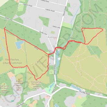
- Distance: 5.1 Km
- Elevation gain: 91 m
- Maximum elevation: 108 m
- Elevation loss: 94 m
- Minimum elevation: 56 m
- Moving time: 1 h 16 m
- Moving speed: 4.0 Km/h
- Maximum speed: 15.0 Km/h
- Total time: 1 h 24 m
- Global speed: 3.6 Km/h
Interactive trail map
Trail profile
- Distance: 5.1 Km
- Elevation gain: 91 m
- Maximum elevation: 108 m
- Elevation loss: 94 m
- Minimum elevation: 56 m
- Moving time: 1 h 16 m
- Moving speed: 4.0 Km/h
- Maximum speed: 15.0 Km/h
- Total time: 1 h 24 m
- Global speed: 3.6 Km/h
About this trail
Name: The Devil's Jumps Loop trail, distance, elevation, map, profile, GPS track
Coordinates: 51.14867 -0.76597 51.15625 -0.74312