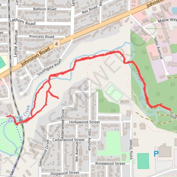
Scott Kenny Trail along Roger Creek
- Distance: 3.7 Km
- Elevation gain: 67 m
- Maximum elevation: 38 m
- Elevation loss: 70 m
- Minimum elevation: 15 m
- Moving time: 50 m 28 s
- Moving speed: 4.4 Km/h
- Maximum speed: 9.1 Km/h
- Total time: 59 m 10 s
- Global speed: 3.8 Km/h
Interactive trail map
Trail profile
- Distance: 3.7 Km
- Elevation gain: 67 m
- Maximum elevation: 38 m
- Elevation loss: 70 m
- Minimum elevation: 15 m
- Moving time: 50 m 28 s
- Moving speed: 4.4 Km/h
- Maximum speed: 9.1 Km/h
- Total time: 59 m 10 s
- Global speed: 3.8 Km/h
About this trail
Name: Scott Kenny Trail along Roger Creek trail, distance, elevation, map, profile, GPS track
Coordinates: 49.25754 -124.80530 49.26191 -124.79052
Other hiking, mountain biking, running and outdoor activity trails
Click on a trail to view its statistics, map and profile.
Sproat Lake - Nanaimo
Canada > British Columbia > Alberni-Clayoquot Regional District > Area D (Sproat Lake)
Distance: 87.0 Km • Elevation gain: 1,273 m • Maximum elevation: 422 m
Parks paths
Canada > British Columbia > Regional District of Nanaimo > Parksville
Distance: 48.7 Km • Elevation gain: 918 m • Maximum elevation: 424 m