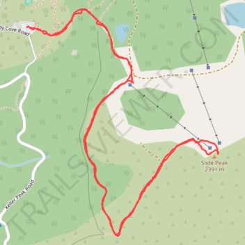
Slide Peak trail
- Distance: 3.7 Km
- Elevation gain: 154 m
- Maximum elevation: 2,385 m
- Elevation loss: 153 m
- Minimum elevation: 2,231 m
- Moving time: 1 h 17 m
- Moving speed: 2.9 Km/h
- Maximum speed: 4.9 Km/h
- Total time: 1 h 37 m
- Global speed: 2.3 Km/h
Interactive trail map
Trail profile
- Distance: 3.7 Km
- Elevation gain: 154 m
- Maximum elevation: 2,385 m
- Elevation loss: 153 m
- Minimum elevation: 2,231 m
- Moving time: 1 h 17 m
- Moving speed: 2.9 Km/h
- Maximum speed: 4.9 Km/h
- Total time: 1 h 37 m
- Global speed: 2.3 Km/h
About this trail
Name: Slide Peak trail trail, distance, elevation, map, profile, GPS track
Coordinates: 34.20137 -117.04364 34.20858 -117.03626
Other hiking, mountain biking, running and outdoor activity trails
Click on a trail to view its statistics, map and profile.
Big Bear - San Bernardino National Forest
United States > California > San Bernardino County > Highland
Distance: 61.0 Km • Elevation gain: 3,536 m • Maximum elevation: 2,429 m