Thank you for supporting this site ❤️
Make a donation
Make a donation
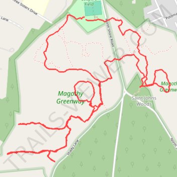
Magothy Greenway Trails
- Distance: 9.0 Km
- Elevation gain: 37 m
- Maximum elevation: 20 m
- Elevation loss: 38 m
- Minimum elevation: 2 m
- Moving time: 1 h 45 m
- Moving speed: 5.1 Km/h
- Maximum speed: 19.5 Km/h
- Total time: 1 h 45 m
- Global speed: 5.1 Km/h
Interactive trail map
Thank you for supporting this site ❤️
Make a donation
Make a donation
Trail profile
- Distance: 9.0 Km
- Elevation gain: 37 m
- Maximum elevation: 20 m
- Elevation loss: 38 m
- Minimum elevation: 2 m
- Moving time: 1 h 45 m
- Moving speed: 5.1 Km/h
- Maximum speed: 19.5 Km/h
- Total time: 1 h 45 m
- Global speed: 5.1 Km/h
Thank you for supporting this site ❤️
Make a donation
Make a donation
About this trail
Name: Magothy Greenway Trails trail, distance, elevation, map, profile, GPS track
Coordinates: 39.09254 -76.49720 39.10397 -76.48091
Thank you for supporting this site ❤️
Make a donation
Make a donation
Other hiking, mountain biking, running and outdoor activity trails
Click on a trail to view its statistics, map and profile.